The Grid and the Mud | by Dino Buzzi
...



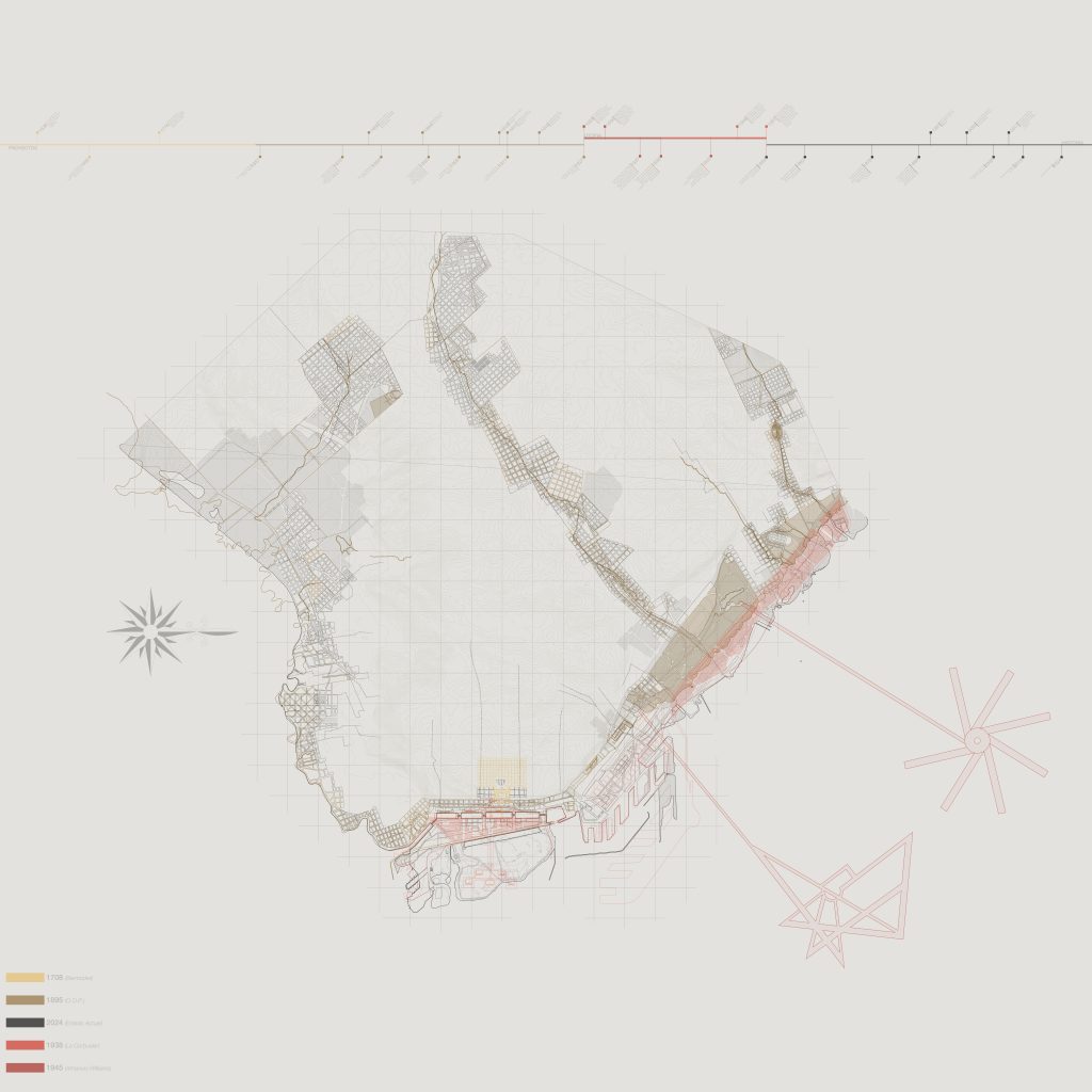
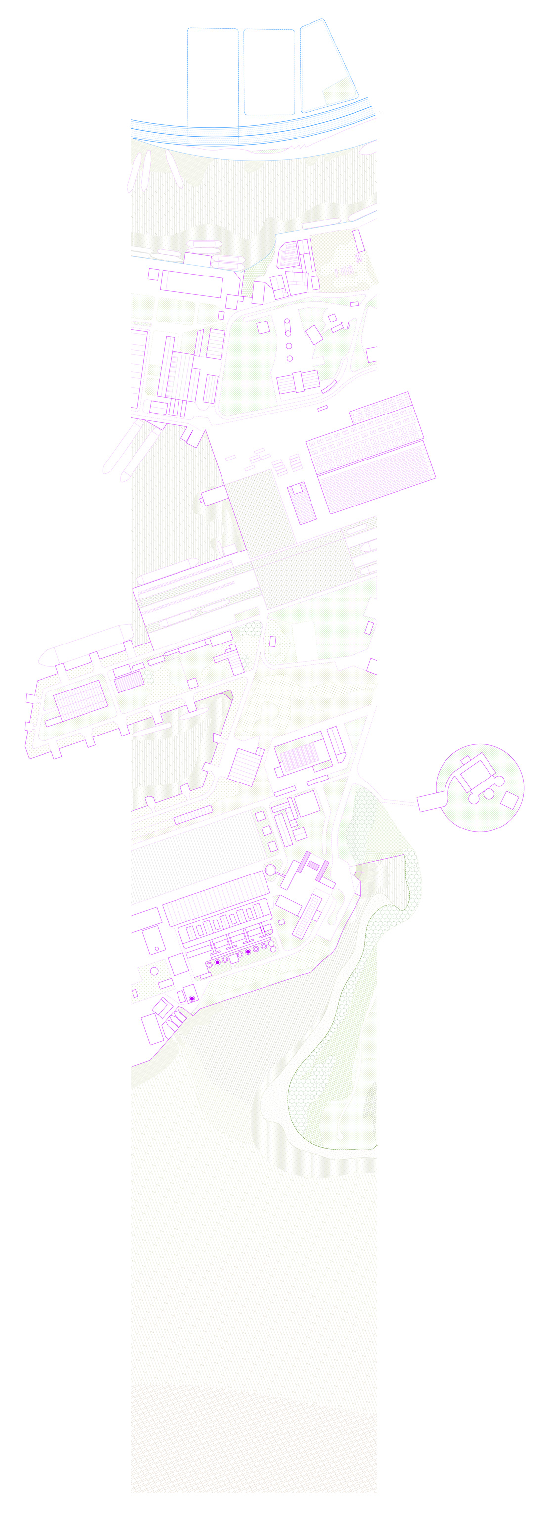
The encounter between the Río de la Plata and Buenos Aires is a space artificially constituted as a frontier. The edge is defined as the thickness running from the original limit of the Río de la Plata to the current limit, after the growth of the city over the river. In this sector, a city conceived as a generic grid is placed under tension by the contingency of the river and its accidents (hills, lagoons, ports, etc.). The result of this tension yields different kinds of configurations: some more abstract, others more contingent. This edge of the river is inhabited by ships, ports, trucks, highways, and housing.
How was the space between the river’s original limit and its current limit occupied? The stretch running from Catalinas Norte to the Riachuelo describes the territorial and political disputes surrounding Eduardo Madero’s project for the Port of Buenos Aires.
.
Walking through the space of the Paseo Colón arcade is perhaps one of the most characteristic urban situations of the city. Its measure and its commensuration resonate with the behavior of the city: it shelters us from the likely porteño rain, while, accompanied by the rhythmic columns, we can go on seeing the avenue and what was once the limit of the river. There we find a traditionally porteño fragment of city, with a consolidated front line. This morphology is explained by the reminiscence left by the building of La Recova de la Carne,¹ which was demolished in 1883. Around 1890, ordinances came into effect setting out regulations for the buildings placed along the river’s edge, while on the other margin (where the river had previously been) the rules were laxer. This fragment, from Paseo Colón to the current riverfront, is defined by the pregnancy of the regular urban grid inherited from the Spanish conquest: a grid of orthogonal blocks. This configuration was affected, around 1855, by the desire to have a port in this part of the city. In this way, the territory reclaimed from the river through landfill beginning in 1887 entered into a functional-formal dispute embodied in the projects of Luis Huergo and Eduardo Madero. It was the engineer Eduardo Madero who won the dispute: in 1882, he was put in charge of the execution of the port (the North and South Docks and the basins). However, in 1908 a law was passed convening a new competition to extend the port, because Madero’s project had proved inefficient. Analyzing this strip, we can clearly see how Madero’s ideas prioritized the geometric continuity of the urban grid over the shape the river demanded in order to function as a port. Huergo proposed a system of combs at 45°, which ultimately shaped the construction of the Puerto Nuevo in Retiro, still in operation today. In the following stretch, after the basins, we can see a series of towers, whose origin is the urban project of the Corporación Puerto Madero. The sale of these state-owned lands was made possible by the state reforms carried out by Carlos Saúl Menem.² In 1991, a National Ideas Competition for Puerto Madero was convened, which laid out the urban plan for this fragment. The Parque de las Mujeres Argentinas is a key piece for understanding the intent of the project. It operates as a mediation between the geometry of the Spanish grid city and the contingency of the river.
In the final stretch of this strip appears the Reserva Ecológica.³ This territory has its origin in the Urban Highways Plan carried out in 1976 under the military dictatorship. By dumping the rubble produced by the construction of the highways, a total of 300 hectares were filled in 1977. In 1986, in the context of Alfonsín’s government and the return to democracy, the fill lands were declared a Natural Park and Ecological Reserve. The tension between this piece of landscape and the ultra-luxury buildings located on the last block of Puerto Madero is materialized in the successive fires in the Laguna de los Patos,⁴ which paused due to the real-estate crisis from 2010 onward.

At the encounter of the Río de la Plata with the Riachuelo, we find a piece of an infrastructural character. The southern side of Isla Demarchi is not only the political boundary between the city and its periphery, but also the moment where the continuity between the urban fabric and the river’s edge breaks down. Studying the growth of the urban footprint over the years, we can see that this area is not part of the linear continuity of the founding, abstract grid of the downtown. There, where the river broke, the La Boca Railway was established in 1857, generating a change in the direction of the fabric, since the origin of the La Boca neighborhood forms around the station and toward the Vuelta de Rocha, aligning with the railway.
Isla Demarchi originates from the accumulation of sand and mud, and gradually changes its morphology through a series of landfills. Until 1879 there are records of very informal uses. In that year, President Avellaneda installed there the Naval Workshops of the Navy for the maintenance of the Armada’s vessels. In Pedro Uzal’s map of the same year, a record of these sediments and cluster of islands in this sector appears for the first time. It would only be after the launch of the Puerto Madero project that a slightly more extensive but still very narrow territory would be consolidated. The shape Madero assigned to the south dock is strongly modified due to the landfills carried out later in the area. In the Official Wall Map produced by the Cadastre Directorate in 1945, we can begin to see the comb shape it has today. It is important to note its formal similarity to the Puerto Nuevo (Huergo’s project) completed in 1926. These landfills were directly related to the growth of the TANDANOR shipyard and, later, to the installation of the Central Costanera,⁵ tendered in 1959 and dependent on SEGBA. Both the shipyards and the power plant were sold during the neoliberal government of Carlos Menem. In 1999, the private company in charge of TANDANOR declared bankruptcy. TANDANOR was re-nationalized in 2007 (Decree 315, Néstor Kirchner), with the Ministry of Defense taking possession of 90% of the shares.
In this fragment, after the south dock, there is no continuity with the urban fabric: there are no signs that the city lying behind the highway generates any impact on the geometric organization of the island. In this way, the organization of the territory here is constituted not from the city (field) but from the infrastructure (object). It is the buildings and their productive logics that define the configuration of this piece and resist the territorial disputes installed in the rest of the island (e.g., the former Ciudad Deportiva de la Boca). The Ricardo Balbín Highway⁶ functions as a forceful boundary: it completely cuts off the continuity of the vehicular-pedestrian circulation routes at this exact point. The block, occupied by Silos Areneros Buenos Aires (SAC), no longer reaches the edge of the avenue; it passes beneath it, and from there southward the fabric disappears as such.
The differences in the configuration and organization of these two pieces seem to allow us, at least partially, to see and study how the idea of a generic city produced by a regular, square grid is placed under tension by its constant collision with contingencies: territorial, political, geographic, or productive.
Es arquitecta, graduada con honores de la Facultad de Arquitectura, Diseño y Urbanismo de la Universidad de Buenos Aires. Desde el año 2019 se desarrolla como profesional independiente. Su práctica se centra en la búsqueda de entender lo contemporáneo (diferenciado de lo actual) desde una mirada crítica de la forma arquitectónica asociada a la termodinámica, el contexto territorial y la necesidad de construir un hábitat estimulante para la vida cotidiana más allá de la producción de imágenes. Es docente titular en la Universidad Torcuato Di Tella, espacio en el cual investiga la relación entre tecnología-forma-territorio. Se formó como docente en la cátedra de Roberto Lombardi (2020-2023) y fue docente adjunta, en la asignatura Taller de Tesis (cátedra Adamo - Faiden 2023-2024),